
Profile of Scientist and Scientific Staff

Geosciences Department (GSD) is one of the oldest departments of IIRS established in 1966 in collaboration with The ITC, the Netherlands, to provide professional training to scientists and technical staff of government and public sector organizations dealing with geoscientific applications such as geological survey and mapping, groundwater resource assessment, mineral targeting and hydrocarbon exploration, and engineering geological mapping. Presently, the department has been evolved into a full-fledged entity for conducting training, education and R&D activities and national level projects on geological resource appraisal and hazards assessment. Significant contributions of the department are as follows:
- Produced landmark geological maps: (a) geological map of Garhwal Himalaya (1970s), (b) geological map of Cuddapah Basin (1970s-1980s), (c) hydromorphogeolocal maps of different parts of the country including Cuddapah, Vindhyan, Doon valley and surroundings (1970s-1980s), (d) groundwater prospect and quality map of NCR Delhi (2000s);
- Provided geological input in many national and international projects: (a) Highway Alignment Project in Nepal (1980s), (b) Parbati Hydroelectric Project (1980s-1990s);
- Prepared Landslide Hazard Zonation and Seismic Microzonation maps: (a) along the pilgrimage route corridors in U.K. and H.P. states in Northern India (1990s-2000s), (b) national highway along Shillong-Silchar-Aizawl route corridor in NE India (2000s), (c) seismic micro-zonation of Doon valley in collaboration with ITC, the Netherlands and Wadia Institute of Himalayan Geology, Dehradun (2000s);
- Produced numerically simulated physically based models (debris flow) along with rainfall thresholds to help mitigation, slope vulnerability, susceptibility, risk due to landslide hazard in the Garhwal Himalaya (2013-til date)
- Provided advisory support in National Geomorphological and Lineament Mapping Project of ISRO in collaboration with Geological Survey of India, in numerous developmental and geohazard projects of Uttarkahand state and Public Sector enterprises (2010s)
- Development of complete spectral library (0.4-16µm) of Proterozoic rocks/ minerals of Aravalli-Delhi Fold belt in Eastern Rajasthan
- Provided satellite derived data products for mineral abundance/ target maps (space-borne and airborne) and understanding metallogeneis in parts of Rajasthan and Odisha, in collaboration with Geological Survey of India.
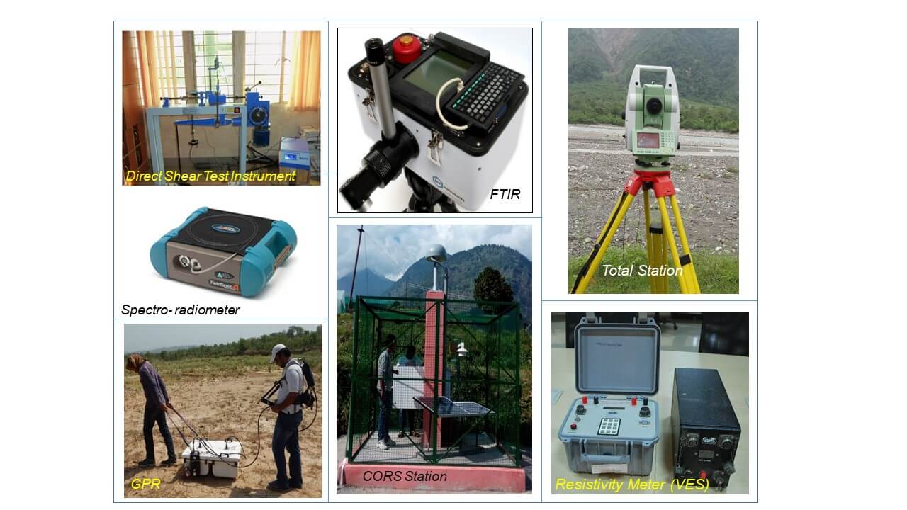
The state of the art facility in the department includes ‘hypespectral lab’, ‘engineering geological lab’ and ‘geophysical lab’ hosting VNIR-SWIR spectroradiometers, FTIR spectrometer for infra-red region (2-16 mm), multi-frequency bi-static ground penetrating radar (GPR), vertical electrical sounding, IP resistivity meter, permanent GNSS stations (CORS), dual frequency geodetic GNSS systems, seismic stations with broad band seismometer (BBS) and strong motion accelerograph (SMA), 48 channel engineering seismograph, and direct shear and tri-axial shear strength apparatus for measuring geotechnical properties of rocks and soils.
The present R&D thrust areas of the department includes:
- Mapping, monitoring and modelling of landslide, engineering geological study for slope stability analysis and infrastructure development
- Co-seismic and inter-seismic deformations, geodynamics of Himalaya and earthquake precursor study
- Microwave remote sensing and SAR interferometry for monitoring of land surface deformation due to earthquake, mining and groundwater depletion
- Hyperspectral image analysis for mineral abundance mapping and targeting
- Glacier morphology, spatio-temporal dynamics and climate change study
- Planetary geology of Moon and Mars including characterization of planetary surface and processes
- Space gravity data (GRACE FO) analysis for ground water depletion study over Indian regions
- Thermal remote sensing for thermal anomaly detection and monitoring of geological phenomena
In many of the R&D projects, the department has been collaborating with the premiers academic and R&D organizations and stakeholders in the country: (1) Wadia Institute of Himalayan Geology, (2) Geological Survey of India, (3) Central Ground Water Board, (4) Survey of India, (5) IIT (ISM) Dhanbad, (6) Central Institute of Mining and Fuel Research, CSIR, (7) Coal India Ltd., (8) Aryabhatta Research Institute of Observational Sciences, Nainital.
Regular Courses:
Geosciences conducts full time academic M. Tech. course in collaboration with Andhra University along with Nine Months PG Diploma course in RS & GIS
- M.Tech. in Remote Sensing and GIS (Specialization: Geosciences)
- P.G. Diploma in Remote Sensing and GIS Applications for Natural Resources Management (Specialization: Geosciences)
- PG Diploma in Remote Sensing and GIS Course of CSSTEAP (UN)
- NNRMS course in RS and GIS Technology and Applications for University/Institute/College Teachers (Specialization: Geosciences)
Special Courses:
Geosciences conducts user defined special and customized courses of different durations. The main focus of these courses are to met the specific requirements of user segments for applications for RS & GIS in and geosciences and related areas such as:
- Microwave remote sensing and SAR interferometry for geological applications
- Hyperspectral image analysis for mineral targeting and abundance mapping
- Spaceborne geodetic observations for applications in seismicity and geodynamics
- Hazard zonation, monitoring and modelling of Landslide and support to early warning system
- Lunar Remote Sensing and Applications
- Himalayan Cryospheric Studies under Changing Climate
- GNSS and Spaceborne Gravity Data Analysis and Applications
Additionally Geosciences Department has been providing guidance to the students/ researchers enrolled in the following programmes:
- Post Doctoral Fellows in Earth Sciences/Remote Sensing
- Ph. D in Earth Sciences/Remote Sensing
- Post Graduate in Earth Sciences/Remote Sensing /Geoinformatics/ Geomatics
- Summer Internship for Post Graduate and Graduate level students
- Geodynamics and Seismicity Investigations in North-Western Himalaya.
- Mapping, Modeling and Impact Assessment of Land Subsidence in Northern India.
- Rainfall Threshold based Predictive Modelling of Slope Failure, Movement Detection and Deformation Modelling of Landslide in Garhwal Himalaya.
- Study of seasonal variation of Stress and Strain distribution using GNSS and Correlation with Seismic Activity in Northwest Himalaya
- Chandrayaan-2 Science Plan for utilization of Imaging Infrared Spectrometer (IIRS) Data for lunar surface compositional mapping
- Rainfall Threshold Modelling for initiation of landslides and decoupling of spatial variations in precipitation, erosion, tectonics in Garhwal Himalaya (DMSP); and DInSAR and temporal InSAR based landslide movement detection and modeling (DMSP).
- GNSS receiver and analyser (CORS and CMGI)
- Thermal Imaging Camera
- Ground penetrating radar (600/200/100/40/25 MHz)
- IP and Earth Resistivity meter (40 Channel ERT)
- 48 Channel Engineering Seismograph
- Seismic station (BBS and SMA)
- Thermal spectro-radiometer
- Laser Distance Meter and Total station system
- Portable weather station and Field weather station
- Vibrating wire Piezometer and Multi-point Borehole Extensometer
- GPS with barometer and Field camera, compass
- Earthquake Early Warning System
- Vertical Electrical Sounding (VES)
Hardware/Software
- Advance computing facility: Workstations, Desktops, Laptops
- ERDAS Imagine, Leica Photogrammetry Suite, RAMMS, SARSCAPE, GAMMA, ArcGIS, SPSS, Matlab, ENVI, IDL, Trimble Pivot, Leica Spider, GAMIT/GLOBK, GMT, Bernese, SWAN, RES2DINV, RockWorks, Geotest and Summit acquisition software.
Laboratories
- Hyperspectral Lab – VNIR, SWIR and TIR range spectral analysis of rocks and minerals
- Engineering geology lab: geotechnical instrument to determine compressive, tensile and shear strength of rocks/soil
Photographs of Recently executed field works & projects

A) As a part of ISRO-NASA AVIRIS project campaign, field spectra were collected at Matun rock phosphate mine, Udaipur, Rajasthan. B) Multi-channel engineering seismograph based survey for Vs30 determination and seismic hazard analysis.

Detection of Ground water using geophysical surveys [ A) Multi-Channel IP resistivity, B) VES resistivity] in fracture zones identified by satellite image interpretation in Mussoorie hills.

As a part of ISRO EOAM project, campaign mode survey using geodetic GNSS receivers is carried out by GDMS, IIRS to establish Indian plate motion and crustal shortening of Himalaya.

DInSAR based observation was compared with sub-surface observation by drilling bore wells up to a depth of 100-120m and by installing vibrating wire multi-point borehole extensometer (MPBX) and vibrating wire piezometer at selected test sites in NW India.

As a part of the ongoing EOAM project on Geodynamics and Seismicity of western Himalaya, Three Continuously Operating Reference Station (CORS)/ Global Satellite Navigation System (GNSS) stations have been installed at Pant Nagar Mussoorie and Gopeshwar.

As a part of the ongoing EOAM project on Geodynamics and Seismicity of western Himalaya, seismic station consisting of Broadband seismometer and strong motion accelerograph is installed at Mussoorie and Nainital to monitor earthquakes in Garhwal Himalaya.

A) Automated Weather Stations have been installed at Joshimath, Tangni to model rainfall triggered landslides in Garhwal Himalaya. B) Active faults interpreted from satellite images are confirmed by Multi-frequency Ground Penetrating Radar survey.

A) Engineering Geology laboratory, augmented at GDMS, IIRS to support landslide modelling. B) Hyperspectral lab, augmented at GDMS IIRS.
Phone : +91-135-2524154
Email : gsd[at]iirs[dot]gov[dot]in
Address : 4, Kalidas Road,Dehradun- 248001 India

