Profile of Scientist and Scientific Staff

The Forestry and Ecology Department was established in 1966 with the aim of providing training and skill development on the utility of aero-space remote sensing for forest resource inventory, monitoring and management for forest managers in particular and scientific community in general. Nationwide forest cover mapping & nationwide biome level characterization of Indian forests biodiversity at landscape level are the three major projects planned and executed by the department. A few other important research projects carried out by the department are - growing stock and biomass assessment, wildlife habitat modelling, sustainable development planning, national level carbon flux measurement and modelling, national level vegetation carbon pool estimation in India, ecosystem dynamics and hydrological modelling in north-eastern region, wildlife habitat evaluation in Ranikhet and Ranthambore Tiger Reserve, national level biome classification of natural vegetation, grassland mapping and carrying capacity estimation. The capacity building and research activities of the department are-
- Organization of short courses on RS & GIS applications in Forestry for the line departments, Use of RS & GIS in forest working plan, Impact of climate change in forestry.
- Organization of short courses through IIRS Distance Learning Program on RS & GIS in applications for State forest Departments.
- Organization of special courses following the National Meet and meeting the Ministries' requirements.
Regular Courses:
- M.Tech in Remote Sensing and GIS with Specialization in Forest Resources & Ecosystem Analysis.
- Post-Graduate Diploma Course in Remote Sensing and GIS with Specialization in Forest Resources & Ecosystem Analysis.
- NNRMS-ISRO Sponsored Certificate Course for University Faculty.
Special Courses:
Forestry and Ecology Department conducts user defined special and customized courses of different durations. The main focus of these courses are to met the specific requirements of user segments for applications for RS & GIS in and forestry and related areas such as:
- One-Week Refresher Training Course for IFS Officers on Remote Sensing and GIS Applications in Working Plan Preparation.
- A Special Course on Remote Sensing and GIS Applications in Carbon Forestry for the Forest Range Officers from Bangladesh Forest Department.
- A Special Course on Application of Remote Sensing and GIS in Forestry and Wildlife Research for Research Scholars from Jammu University.
- A Special Course on Advanced Course on Remote Sensing and GIS in Forestry Applications for UPRSAC Project Scientists.
- Biodiversity Characterization, Species distribution modeling, plant invasion risk modelling.
- Synergistic use of advanced sensors (hyperspectral, LiDAR, microwave and GPR) for forest biophysical and biochemical parameters retrieval.
- Carbon pool and flux measurement for forest productivity assessment.
- Ecosystem vulnerability assessment, Forest fire risk modelling and Prediction.
- Climate change impact on forests and ecosystems - modelling species loss & changes in plant communities.
- Ecological and wildlife corridor modelling and connectivity analysis.
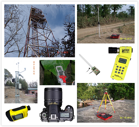
FED is equipped with state-of-art education, training, research and web-enabled data dissemination facilities

- Carbon Flux towers at Barkot and Haldwani
- Automatic Weather Stations (27 installed)
- GPS (Trimble, Garmin, etc.)
- Spectro-radiometer
- Digital Plant Canopy Imager
- Ceptometer
- Photosynthetic Analyzer
- Increment Borers
- Spherical Crown Densiometer
- Chlorophyll concentration meter
- Binocular
- Tree Calipers
- Forestry Pro Hypsometer
- Dendrometer
Completed
- Wasteland development planning using GIS in Puruliya district.
- Biome Level Classification of Natural Vegetation in India.
- Biodiversity Characterization at Landscape Level using RS and GIS in India (DOS-DBT). (145 KB)Language: English
- Biodiversity Information System (BIS). (82.5 KB)Language: English
- Indian Bioresource Information System (IBIN). (94.8 KB)Language: English
- Ranthambore Tiger Reserve for conservation Planning, Rajasthan.
- Wildlife habitat modelling and evaluation in Rajaji National Park.
- Habitat modeling in Kaziranga Conservation Area in Kaziranga National Park.
- Ecosystem Dynamics and Hydrological modelling in North-eastern Region.
- Sustainable Watershed Development Planning in Pathri Rao Sub-watershed.
- Carbon Budget Assessment in Terrestrial Ecosystem of Arunachal Pradesh.
- Grassland Mapping and Carrying Capacity Estimation in Himachal Pradesh and Madhya Pradesh.
- Vulnerability to Climate Change Analysis in the Hill Region of Darjeeling Himalaya.
- Characteristics of Forest & Plantations using SAR.
- Demarcation of Eco-Sensitive Zone along the Bhagirathi river in Uttarkashi district, Uttarakhand.
- RISAT C-band quad–pol data utility for forest resources inventory (SAC).
- Eco-sensitive Zone Mapping of Bhagirathi catchment areas from Gaumukh to Uttarkashi
- Mapping National Parks and Sanctuaries in India.
- National Carbon Project: Vegetation Carbon Pool assessment. (189 KB)Language: English
- Evaluation of PolInSARdata for forest biophysical parameters retrieval
- Optimizing parameters from multiple sensors for biomass estimation
- Application of space-borne LiDAR and optical data for studying above ground forest biomass (213 KB)Language: English
Ongoing
- National Carbon Project : Soil, vegetation-atmosphere carbon flux modelling (153 KB)Language: English
- Vulnerability assessment of Mountain Ecosystems due to Climate change: Ecosystem Structure and Functioning (148 KB)Language: English
- Forest Fire Risk Modelling (154 KB)Language: English
- Biodiversity Characterisation at Community level (DBT-DOS) (154 KB)Language: English
- L & S Band SAR for Forest Biomass and Disturbance Assessment (DOS) (154 KB)Language: English
Phone : +91-135-2524171
Email : fed[at]iirs[dot]gov[dot]in
Address : 4, Kalidas Road,Dehradun- 248001 India


